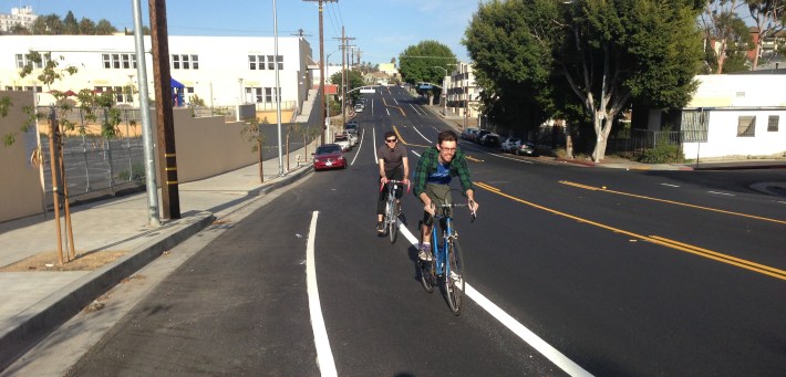
Earlier in 2014, the national Streetsblog Network website highlighted BikeSD's coverage of the city of San Diego's first road diet bike lanes. Streetsblog Los Angeles has covered quite a few city of Los Angeles road diets over the past few years; most of them non-controversial, including 7th Street, Grand Avenue, Hoover Street, and Myra Avenue. A few of these projects have encountered criticism; examples include Motor Avenue and Wilbur Avenue.
Speaking at yesterday's Bicycle Plan Implementation Team (BPIT) meeting, the city of Los Angeles Department of Transportation's (LADOT) Bikeways engineer Tim Fremaux remarked that LADOT had implemented 53 road diet bike lane projects. Fremaux clarified that these road diets are generally "safety projects," reducing speeding, making it easier for pedestrians to cross, and that adding bike lanes tended to be almost incidental to the overall purpose. Fremaux smiled stating that he has been happy to add a lot of new left turn lanes where they had not been before.
Fremaux provided Streetsblog the list of projects [PDF] which shows over 50 miles of road diet bike lanes. Fremaux revised the list after yesterday's meeting, increasing the total to 54 road diets. The projects listed were completed from 1999 to 2014, with the vast majority completed since 2011, after approval of the 2010 Bike Plan and Mayor Villaraigosa's subsequent 40-new-miles-per-year bikeway directive.
For readers unfamiliar with road diets, this Streetfilm provides a good guide. Generally road diets remove one car lane and replace it with two bike lanes, though there are variations. Road diets have been shown to improve safety for all road users, especially by removing blind spots for turning drivers.
The list of LADOT road diet streets follows the jump.
- Silver Lake Boulevard - Glendale Blvd. to Reservoir St. - 1.6 miles
- York Boulevard - Eagle Rock Blvd. to South Pasadena City Limit - 2.7 miles
- Hoover Street - 109th St. to 120th St. - 0.9 miles
- Myra Avenue - Fountain Ave. to Santa Monica Blvd. - 0.4 miles
- Wilbur Avenue - Devonshire St. to Nordhoff St. - 1.5 miles
- Via Dolce - Washington Blvd. to Marquesas Way - 0.4 miles
- 7th Street - Catalina St. to Main St. - 2.8 miles
- Spring Street - Cesar E. Chavez Ave. to 9th St. - 1.4 miles
- Main Street (Venice) - Santa Monica City Limit to Windward Cir. - 0.8 miles
- Main Street (Downtown) - 1st St. to 16th St./Venice Blvd. - 1.7 miles
- Winnetka Avenue - Devonshire St. to Nordhoff St. - 1.7 miles
- Los Angeles Street - Alameda St. to 1st St. - 0.5 miles
- 1st Street - Beaudry Ave. to San Pedro St. - 1 mile
- Olive Street - 7th St. to Washington Blvd. - 1.2 miles
- Grand Avenue - Wilshire Blvd. to Jefferson Blvd. - 2.2 miles
- Motor Avenue - National Blvd. to Venice Blvd. - 0.7 miles
- Santa Monica Boulevard - Virgil Ave. to Manzanita St. - 0.3 miles
- 8th Street - Boyle Ave. to Olympic Blvd. - 1.4 miles
- Opp Street - Fries Ave. to Banning Blvd. - 0.4 miles
- Wilmington Blvd. - Anaheim St. to C St. - 0.5 miles
- Neptune Ave. - Anaheim St. to C St. - 0.5 miles
- Via Marisol - Monterey Rd. to Lomitas Dr. - 0.2 miles
- Alla Road - Maxella Ave. to Marina Expwy. - 0.6 miles
- Rowena Avenue - Hyperion Ave. to Glendale Blvd. - 0.5 miles
- Cypress Avenue - Jeffries Ave. to Arroyo Seco Ave. - 0.2 miles
- San Pedro Street - Vernon Ave. to Jefferson Blvd. - 0.8 miles
- Griffin Avenue/Zonal Avenue - Altura St. to State St. - 1.1 miles
- 54th Street - 7th Ave. to Arlington Ave. - 0.4 miles
- Capitol Drive - Western Ave. to Gaffey St. - 1 mile
- Westmont Drive - Western Ave. to Gaffey St. - 1.1 miles
- Avalon Boulevard - L St. to Harry Bridges Blvd. - 1.1 miles
- Broad Avenue - Pacific Coast Hwy. to Anaheim St. - 0.8 miles
- San Pedro Street - Florence Ave. to 115th St. - 3.1 miles
- Clybourn Avenue - San Fernando Rd. to Sherman Way - 1 mile
- 25th Street - Mermaid Dr. to Patton Ave. - 1.2 miles
- E Street - Avalon Blvd. to Alameda St. - 0.7 miles
- San Pedro Place - 41st Pl. to Main St. - 0.5 miles
- Mission Road - North Broadway to North Main St. - 0.8 miles
- Compton Avenue - Century Blvd. to 104th St. - 0.3 miles
- Grand Boulevard - Windward Cir. to Venice Blvd. - 0.4 miles
- 120th Street - Vermont Ave. to Main St. - 1 mile
- Broadway (Eagle Rock) - Eagle Dale Ave. to Colorado Blvd. - 0.3 miles
- Colorado Boulevard - Broadway to Figueroa St. - 2.2 miles
- 2nd Street - Glendale Blvd. to Spring St. - 1 mile
- Clybourn Avenue - Victory Blvd. to Vanowen St. - 0.5 miles
- Virgil Avenue - Santa Monica Blvd. to Melrose Ave. - 0.5 miles
- 48th Street - Crenshaw Blvd. to Normandie Ave. - 1.7 miles
- Chase Street - Van Nuys Blvd. to Woodman Ave. - 0.9 miles
- 1st Street - Vermont Ave. to Commonwealth Ave. - 0.4 miles
- San Vicente Boulevard - Bundy Dr. to Bringham Ave. - 0.7 miles
- Loyola Boulevard - Westchester Pkwy. to Lincoln Blvd. - 0.3 miles
- Wilmington Avenue - Century Blvd. to 104th St. - 0.3 miles
- West Boulevard - Slauson Ave. to 68th St. - 0.8 miles
- Califa Street - Topanga Cyn. Blvd. to 200' east of Canoga Ave.- 0.5 miles
Per LADOT, the overall total is 51.5 miles. For additional details on each project (including the before and after configurations), see the LADOT road diet project list [PDF].
Note that LADOT list includes distances and limits show only the road diet portion of each facility. In some cases, including Grand Avenue, there is additional (non-road-diet) bike lane mileage not included. There is at least one project where the city did a short portions of road diet bike lanes that doesn't appear on this list: Main Street (South Los Angeles) from 92nd Street for at least a couple blocks southward. Though they don't necessarily belong on this list, there are also streets where LADOT installed road diets, but did not add bike lanes, for example: Boyle Avenue in Boyle Heights. So the actual road diet and bike lane totals appear to be even higher than what LADOT has claimed.


